nebraska Trails

The " Great American" Route Through Nebraska

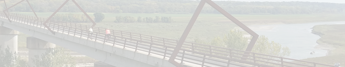
The Great American Rail-Trail crosses from Iowa into Nebraska on the iconic Bob Kerrey Pedestrian Bridge—a 3,000-foot cable-suspension structure over the Missouri River. The preferred route of the Great American Rail-Trail in Nebraska weaves through the urban areas of Omaha and Lincoln, connecting these population centers to the western, more rural, part of the state along one of the longest and most famous rail-trails in the country—the Cowboy Recreation and Nature Trail.

590+
TOTAL MILES

307+
EXISTING
TRAIL MILES

24
EXISTING
TRAILS

52%
COMPLETE

Discover History on the Trail

Diplomatic Reception Rooms

In these 42 rooms, members of the U.S. Department of State meet with diplomats, entertain foreign leaders and engage in other activities of...

Trail: Great American Rail-Trail
State: DC
Architecture Politics, Policy & Justice
Duke Ellington's Birthplace

Edward Kennedy “Duke” Ellington was born in 1899 in a house that used to exist on this site. Today it’s a post office but a mural (by Aniekan Udofia)...

Trail: Rock Creek Park Trails
State: DC
Arts, Entertainment & Sports Black History
Godey Lime Kilns

To find these cool ruins from the 19th century, you’ll have to trek a bit off the beaten path—from the intersection of L Street Northwest and 26th...

Trail: Great American Rail-Trail
State: DC
Architecture Commerce, Economy & Work
See All History

Indiana Trail Reviews

Outstanding!

Very nice space. We are so lucky to have this in Lincoln

A Great Way to Spend a Sunday Morning!

The wife and I thoroughly enjoyed our trip bicycling from the Nebraska side to Iowa and eventually back over on this awesome suspension bridge in October. Plenty of photo ops, pedestrians, and joggers!
Bicyclists: Plan on riding Omaha's Riverfront Trail and Iowa's Riverfront Trail on either side of the bridge to make a day of it! Council Bluff's Tom Hanafan River's Edge Park is especially cool with its large grassy areas, trees, and sculptures!

I've lived in Omaha for 30 years and never knew this route was here. I was able to connect it with side streets and ride from my house near Memorial park to the Bob Kerrey Bridge thus avoiding the major streets with more traffic.

I've lived in Omaha for 30 years and never knew this route was here. I was able to connect it with side streets and ride from my house near Memorial park to the Bob Kerrey Bridge thus avoiding the major streets with more traffic.

Accordion

Good trail

I was traveling through on my way back to Ohio, but I wanted to ride on portions of this trail. I had stayed overnight in Chadron and saw the trail along the road as I drove east. That part was rough looking and not finished as per TrailLink. I never did find a location of a trail head in that area. I stopped in Rushville to see the trail there. The 15 miles between Rushville and Gordon were complete, so the crushed stone was a much better surface. Due to lack of time and not wanting to bike against 25-30 mph winds, I went on to Valentine. I parked in the lot by a grocery store, which was close to the trail. I wasn't sure where else to park in town. I rode the trail to the bridge. While researching this trail, TrailLink had said that the Nicobara Bridge over the Niobrara River was closed, but I was at least hoping to see it. In fact, it was open. It was awesome to see and the views were great. It was a little nerve racking with the winds at 25-30 mph and higher gusts, I felt like I was going to blow over the railing. :-) I went to the parking area on the other side and turned around. I then biked to the trailhead on the west side of Valentine. There is a good ice cream shop on Main Street for those who like to bike to eat treats.
I then drove to Norfolk. The next morning I went to the trailhead there and biked 5 miles out and 5 back. The surface was cement for the first 2 miles, but then changed to crushed stone. Still a good surface. The trail went through the country and along the Elkhorn River.
I did the 2 endpoints, so maybe someday I will ride the middle portion.

Nice walk

Mostly wooded with few road crossings. Storm damage has been cleared. Very pleasant walk from north end on Leavenworth to Vinton Street. Mostly walkers and a couple bikers. Some benches.

Great trail for a 5k!

Great trail for a 5k!

Trail Closed at The Mart for sewer repair

There is a detour but you have to cross Dodge Street. Just wanted to share this info with riders. It closed now and will be for 5 months in this section. https://omaha.com/news/local/omaha-to-close-portion-of-keystone-trail-for-5-months/article_07b99bce-3852-11ee-bb43-3bcb2f7635e1.html

The pipe after the Platte River bridge is bent.

The guard pipe on the south side of the Platte bridge is bent. This narrows the distance between the top of the Guard pipes. It wasn’t enough space for my bicycle handlebars to fit through and so I crashed. I know you don’t want motorized vehicles on the bridge, but the pipes are too tall and interfere with bicycle handlebars, especially when one of them is bent inward. Why can’t the top of the bars be about 10 inches lower? Thank you

Close to the Omaha Metro - Nice Trail!

Parked in the new trailhead in Wabash NE complete with toilet facilities and gravel lot for 20 cars. Rode to Eagle and back. Clean and beautifully maintained crushed gravel trail. Nice bridges. You could probably ride a road bike on it because it was fairly smooth. I rode a mountain bike and my friend had a hybrid. Appx 27 mi round trip. Less than a 40 min drive from Omaha and 45 from Council Bluffs IA.

easy

Easy to navigate, straight forward. Going biking, see you!

Not much here, but it gets the job done

It’s all that they don’t directly connect this to the trail that runs next to Oak Lake. That said, there is a sidewalk that connects them, and I’m not so petty to complain riding on the sidewalk for a couple hundred feet. This way takes you after the Superior St., Trail and Highland Loop, which is useful. For me at least, despite being boring, it gets a bonus star for being literally the only quick way to connect me from UNL Campus to some of my buddies in the Highlands.

Great Trail

The trail was completely open and well maintained. Well worth the 40 minute drive from Two Rivers State Park where we were camping!

not much, but does the job, like N. 1st St. Trail in line with it

It provides a quick way to get from UNL campus to the Highlands, where several of my buddies live. As a biker, I appreciate that it’s paved. I also like it runs next to Oak Lake, although I wish it provided an alternative route around the lake to get some extra scenery. It is also my opinion that this could and should be the same trail as N. 1st St. Trail, but they decided to separate these two by a small section of sidewalk. Oh well.

open

Bridge was recently opened back up over the Platte. Additional upgrades on the east side of the river as well.

A good trail, nowhere close to living to its full potential

As a biker, I appreciate the route that this trail takes. It’s not the most scenic, but it certainly is scenic nonetheless, not so much in nature, but in old historic views. My pet peeve, and it’s a big one, is that it’s crushed limestone. This would be forgivable if it were a straight trail, but it’s one of the curviest out of all the bike trails. It also has parts where the surface is actually slanted, which is frankly unreliable if you’re not ready for it. I watched one of my buddies with my own eyes slide across the limestone surface and down the bank of Salt Creek (yes he was ok) when he rounded a bend too fast. This will all be avoided if they would finish paving this trail like they started to do with the northern area of it, and that alone would add two extra stars to the rating, possibly all three depending on if they fix the slant of the surface

Nice Trail

I enjoy the trail, as long as the city keeps the grass/weeds cut. Be on the look out for broken glass in the area near 42nd & D st.
And yes be careful crossing at 50th St...I can say someone runs the light almost everytime I used the lights.
It would be nice if there was a bench between 50th-42nd St.

feels a bit utilitarian (mostly because Superior Street is boring) but it has some interesting places

As the title says, the trail itself feels a little bit utilitarian. I probably wouldn’t pick this one to go on a fun leisurely ride. That said, I’m very glad this is here, because I don’t want to ride in the road and I hate riding sidewalks. There are times when you need to take this direction to get to places, whether they be stores like The Home Depot near 27th and Superior, or other trails like Highland Loop or Dietrich Connector. I also appreciate this trail is paved.

Get tired legs rideing all the trails that comes off the vererans memorial trail and the numberass of veiws from 17 miles north of Omaha Neb. to the Iowa and Mo. state line south you won't forget these trails from one to the other

I say this becaus i have made all of these trails one at time sometimes two or three and there is water as you go Have nice trip there is some grades but not bad ones as im 76 235lb so if i can make it you can also

wonderful place!

Nice peaceful walk with nature. Wonderful lake and families taking advantage of it! Everyone should visit Walnut Creek Recreation

Look forward to extension to Flannagan Lake trail

I love riding the West Papio, both north and south from Zorinsky Lake, where i usually connect. The north end is more scenic with trees. It's a shame the West Papio does not connect yet to Flannagan Lake. I see they are working on the Cleveland Blvd road, so that should be a solution once done.

Beautiful

This trail isn't that long for some, but probably long enough for others. I didn't have any problem with the surface of crushed stone. I had gone to Fort Robinson State Park first since I was in the area, but I didn't stay to tour that place or look for the endpoint of the trail there. Instead I drove to Crawford, saw the trailhead and then parked in the city park, which was very close. The park had restrooms where I could change my clothes. (I'm from Ohio and was traveling and biking in various mid-western states). The trail went through part of the town and then to the open country. Buttes could be seen. Some of the trail was tree lined and some in the open. One of the bridges went over White River. Benches and covered shelters were available at intervals along the rail.
At the western endpoint, and after 3 miles and where the red line on TrailLink ended, the trail butted up to a road. One could go on a few other roads and into the main part of Fort Robinson. There were not any signs or maps at that spot, so I don't know where the trail went or ended in the state park. I decided not to do that portion, so I turned around.
I enjoyed the ride and I hope it gets well used.

Explore by City

Explore by City

Explore by Activity

Explore by Activity

Log in to your account to:

  • View trail paths on the map
  • Save trails to your account
  • Add trails, edit descriptions
  • Share photos
  • Add reviews

Log in with Google

Log in with Apple

OR

Register for free!

Join TrailLink (a non-profit) to view more than 40,000 miles of trail maps and more!

Register with Google

Register with Apple

OR

Your account has been deleted.